
Hikes In Ushuaia: A Complete Guide
Are you planning to go to Ushuaia AND love hiking?
Then Ushuaia is your paradise! But first, know how to pronounce this city correctly. It is pronounced as OO-SOO-AAYA. Now let’s dive into the hiking part.
We were lucky to have found the hidden spots for hikes in Ushuaia through local friends and so we wanted to share the best hikes with you. If you love to trek in raw nature and experience a diverse landscape, then you definitely should not miss hiking here in Ushuaia.
Why Should You Hike In Ushuaia?
Hiking in Ushuaia offers stunning landscapes, diverse trails, and a true adventure at the “End of the World.” You’ll trek through glaciers, forests, and coastal paths with breathtaking views of the Beagle Channel and Martial Mountains.
Trails range from easy walks in Tierra del Fuego National Park to challenging climbs like Vinciguerra Glacier. Wildlife like wild horses, condors, and foxes adds to the experience. Whether in summer for lush trails or winter for snow-covered beauty, Ushuaia is a must to hike destination for hiking lovers!
We went to Ushuaia in January and stayed there for one whole month as we were also working. We did many day hikes when the weather permitted.
Hikes in Ushuaia
There are some easy, moderate, and difficult hikes in Ushuaia and you can choose based on the time, weather, and your fitness levels.
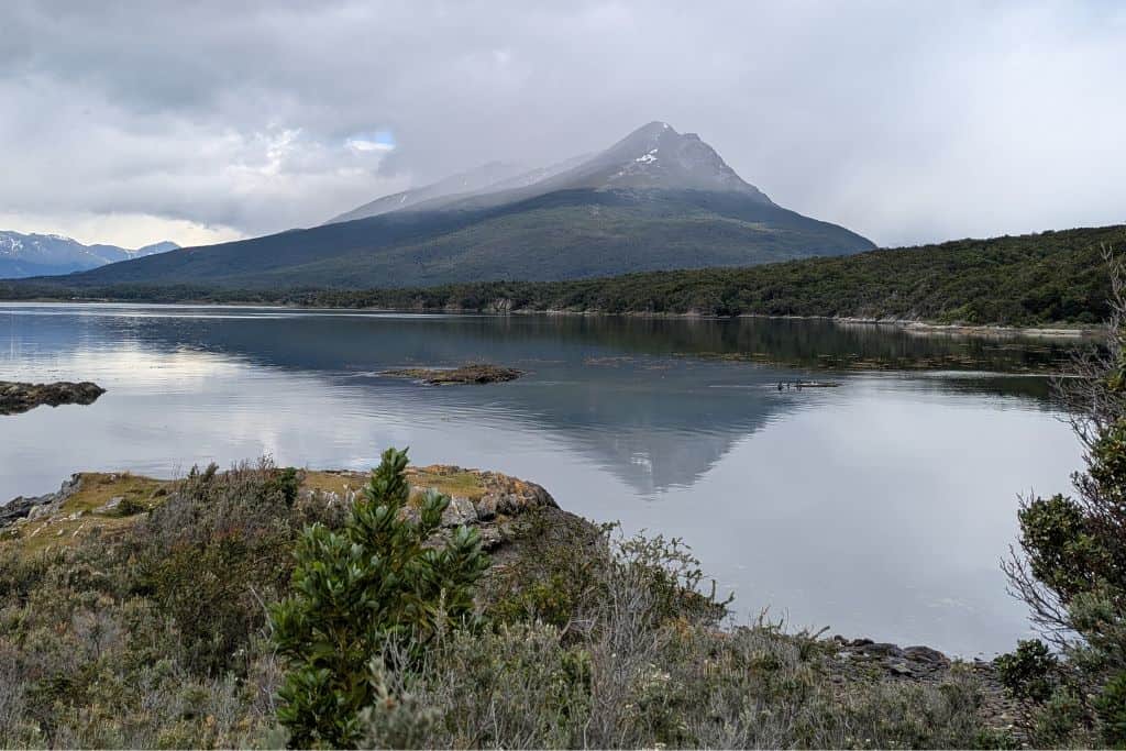
1. Senda Costera del Parque Nacional Tierra del Fuego
- Difficulty Level: Easy
- Distance: 8 km (point-to-point)
- Duration: 3 hrs
- How to get there: You can start from the entrance near Visitor Centre Alakush or from near the End of the World Post office.
There is an entrance fee to the park of 30,000 ARS for foreigners. This rate is only valid until March 2025.
Senda Costera – Tierra del Fuego National Park is a scenic coastal trail offering breathtaking views of the Beagle Channel. This 8 km (5-mile) point-to-point hike connects Ensenada Zaratiegui Bay to Alakush Visitor Center, taking about 3-4 hours.
- Terrain: A well-marked trail with mild elevation changes, winding through forests, rocky shores, and open meadows.
- Views: Stunning panoramas of the Beagle Channel, snow-capped mountains, and small islands.
- Wildlife: Spot Magellanic woodpeckers, horses, foxes, and seabirds along the way.
To get to the National Park, we took an Uber. The Uber will drop you at the entrance of the park from which you have to take a shuttle to reach the trailhead. If you are driving, you can take your car inside and park at the trailhead.
Note – that you will NOT exit to the same starting point so you will have to walk, take the shuttle, or hitchhike back to your starting point to get to your car.
We got lucky as we started early in the morning, Uber driver dropped us at the trailhead. To get out of the park, we hitchhiked back to the entrance from where we could call our Uber.
2. Hike To Cascada de Los Amigos
- Difficulty: Easy to Moderate
- Distance: 9 km (out and back)
- Duration: 3 hours
- How to Get There: The trail starts near the Valle de Andorra area, reachable by Uber.
It is totally FREE to access.
An easy to moderate, this trail leads through a beautiful forest path and marshes to a stunning waterfall. The route is well-marked and mostly flat in the beginning, but then the uphill climb starts. You will be crossing muddy patches, river streams and climbing over some rocks to get close to the waterfall.
It is definitely worth the visit! The hike and the view, both are refreshing!
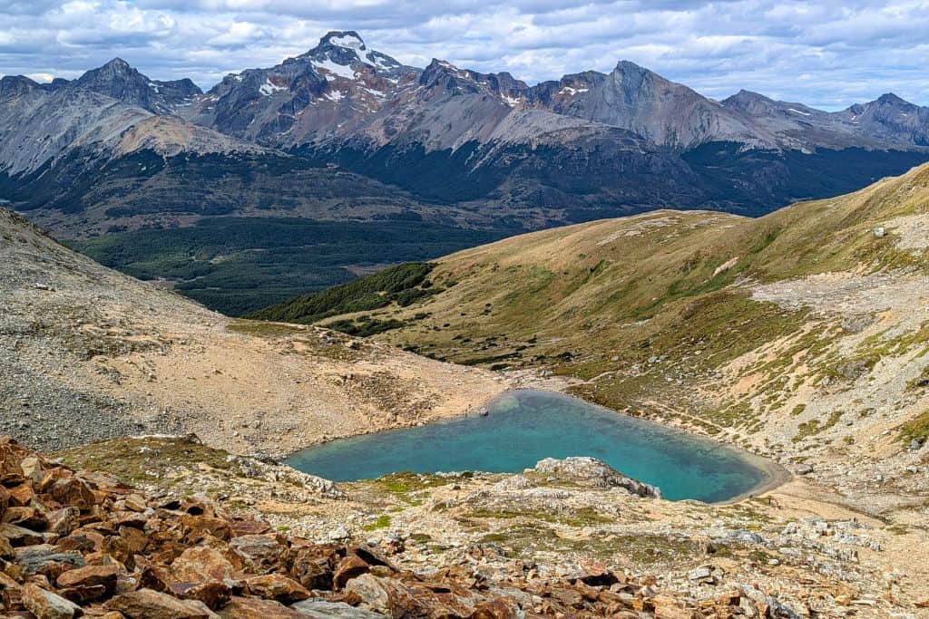
3. Laguna Esmeralda Hike
- Difficulty: Easy to Moderate
- Distance: 9 km (out and back)
- Duration: 3-4 hours (round trip)
- How to Get There: The trailhead is located along Route 3, about 20 km from Ushuaia. You can take a taxi or an Uber.
One of the most famous and FREE hikes in Ushuaia, Laguna Esmeralda is a must-do for visitors. The trail leads through peat bogs, lenga forests, and wooden bridges before reaching the breathtaking emerald-green lake surrounded by towering mountains. It’s a relatively easy hike but is muddy, so waterproof hiking shoes are recommended. Don’t forget to bring snacks and your camera to enjoy the lake and refuel your energy!
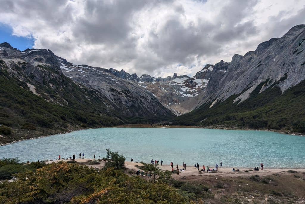
The best part is that it is an easy trail with some slight inclines and declines but you can see people with all fitness levels on this trail.
4. Hike To Ojo del Albino Glacier
- Difficulty: Very Difficult
- Distance: 20 km (round trip)
- Duration: 10-12 hours
- How to Get There: You can continue the trail from Laguna Esmeralda.
Unfortunately, we did not get time to do this hike but since it is so beautiful, I wanted to add this to the blog. For experienced hikers seeking an adventure, Ojo del Albino is a challenging trek leading to a spectacular turquoise glacial lagoon surrounded by jagged peaks.
The trail is long, steep, and often covered in snow, with sections requiring scrambling over rocks and ice. Weather conditions can change rapidly, so proper gear and navigation skills are essential. Some hikers opt to do this trek with a guide.
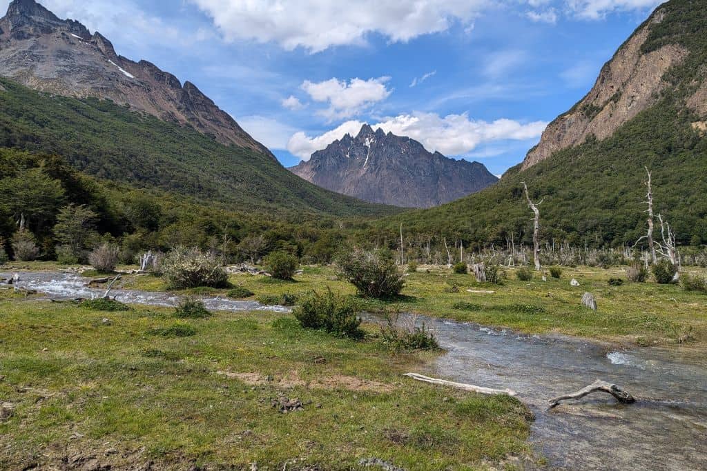
5. Laguna del Caminante Hike
- Difficulty: Challenging
- Distance: 25 km (round trip)
- Duration: 8-10 hours (or overnight)
- How to Get There: The hike begins at Valle de Andorra, accessible by taxi or Uber OR you can start from Cañadon de la Oveja trailhead. We started from the Andorra forest.
This was one of the most remote and rewarding hikes in Ushuaia for us. This trail takes you deep into the Fuegian wilderness. It features dense forests, boggy valleys, and steep ascents before reaching the pristine blue Laguna del Caminante. Many hikers choose to camp overnight near the lake before returning the next day. And why wouldn’t they!? This place is like a piece of heaven. But it can also be easily done in one day.
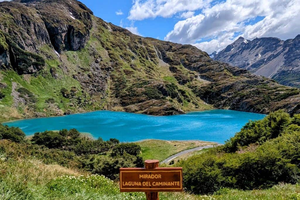
The trail itself is pretty flat with some gentle inclines and declines. The last part though, is a gentle constant uphill. Expect some river crossings and muddy sections. Once you reach the mirador, going to the lake itself is super muddy and there is no proper trail so waterproof boots are highly recommended (and hiking poles too).
There are a couple of water streams along the way from where you can refill your water bottle. We did it and had no issues. Make sure the water is free and fast flowing.
To come back, we chose the same path (Andorra Forest) as the winds had picked up and it was not safe to take the Cañadon de la Oveja trek.
6. Hike To Monte Susana
- Difficulty: Moderate
- Distance: 7 km (out and back)
- Duration: 5-6 hours
- How to Get There: The trailhead is near the entrance of Tierra del Fuego National Park, accessible by taxi or Uber.
Known very less to the tourists, this is a hidden gem mostly known to the locals. You won’t find a lot of people on this trail. Monte Susana offers panoramic views of Ushuaia, the Beagle Channel, and the surrounding mountains. The trail begins in a forested area before climbing steadily along rocky terrain.
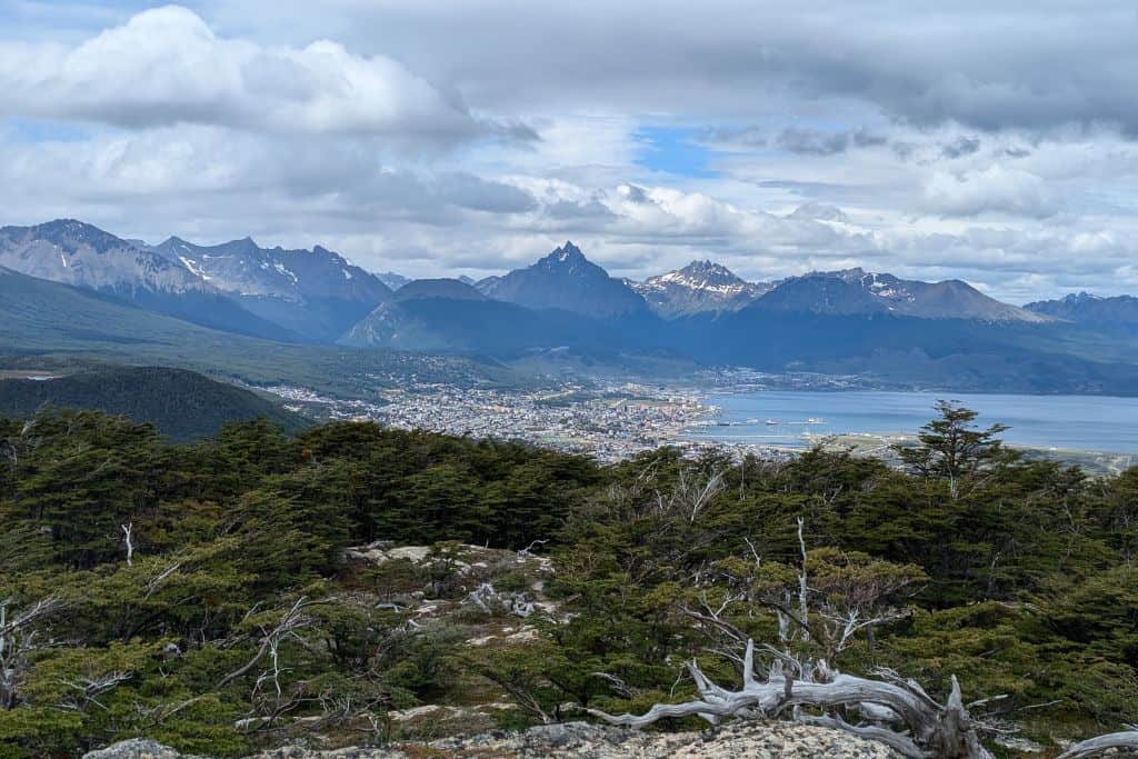
The ascent at the start is a slow gradual and constant uphill but can be steep in certain sections. The reward at the top is a stunning 360-degree view of the region! This is an excellent hike for those looking for a moderately challenging climb with great photo opportunities.
A hint to know when you have reached the summit – when you feel you have reached it, keep going up! The trail is well-marked but some of the last sections are not properly marked so keep some markers for yourself to navigate.
Best part? It is also FREE to access!
7. Laguna Turquesa Hike
- Difficulty: Moderate
- Distance: 5 km (round trip)
- Duration: 3-4 hours
- How to Get There: The trailhead is located along Route 3, about 20 km from Ushuaia. You can take a taxi or Uber. It is right before Laguna Esmeralda on the opposite side.
A shorter but steep hike, Laguna Turquesa rewards hikers with a brilliant turquoise lake surrounded by rugged peaks. The trail begins with a steep incline through a lenga forest before opening up to alpine terrain. Once you enter the meadows after 45 min to an hour of grind, it gets pretty flat with muddy sections.
The final section is rocky, but the view of the glacial lake is well worth the effort. On clear days, you can also see Laguna Esmeralda in the distance.
Do bring trekking poles as the steep ascents and descents can be tough on the knees. If you don’t have it, no problem – grab a wooden stick from the trail entrance!
8. Hike To Vinciguerra Glacier
- Difficulty: Difficult
- Distance: 14 km (round trip)
- Duration: 7-8 hours
- How to Get There: The trail starts in Valle de Andorra, accessible by taxi or Uber.
Another one we could not do but worth adding to the blog. One of the most spectacular hikes in Ushuaia, this trek takes you through peat bogs, lenga forests, and rocky paths before reaching the stunning Vinciguerra Glacier. There used to be ice caves, but when we were there in Ushuaia, the ice caves collapsed.
The terrain can be steep and challenging, especially in wet conditions, so good hiking boots and trekking poles are recommended.
9. Martial Glacier
- Difficulty: Moderate
- Distance: 7 km (round trip)
- Duration: 3-4 hours
- How to Get There: The trailhead is just outside Ushuaia, about a 15-minute drive. Can be accessed by taxi or Uber.
Martial Glacier is one of the most accessible and popular hikes in Ushuaia. The trail begins with a gradual climb through a forested area before opening up to stunning views of Ushuaia, the Beagle Channel, and surrounding peaks. The final section is steep and rocky, but reaching the glacier provides an incredible close-up of the ice formations. In winter, this area is also popular for snowshoeing.
Final Tips for Hiking in Ushuaia
- Pack plenty of snacks and water, as there are no facilities on the trails.
- Check the weather before setting out, as conditions can change rapidly.
- Wear waterproof hiking boots – many trails have muddy or wet sections.
- Bring layers, including windproof and waterproof clothing.
- Start early, especially for longer hikes, to avoid getting caught in the dark.
- Keep trekking poles, as they would make your hike much smoother.
Have 1 or 2 days to hike? Go to Laguna Esmeralda or Laguna Turquesa OR do one long day hike like Ojo de Albino or Laguna del Caminante.
Ushuaia FAQs
– How to get to the city from Ushuaia Airport?
Ubers are the best way to commute here in Ushuaia. You can call one when you arrive at the airport and within minutes, you will be home. Also, they are pretty cheap.
– What should I pack for my trip to Ushuaia?
Well, keep in mind that summer temperatures are maximum of 15-16 degrees centigrade. Weather is unpredictable so expect a lot of wind, days of rain, and sunshine. Keep a fleece, light down jacket, rain jacket, beanie, quick dry pants, and pair of wool socks with you.
Check out all my hiking gear essentials HERE!!!
– Are hikes free in Ushuaia?
Good news! All the hikes mentioned above (except Tierra del Fuego National Park) are free and easily accessible! Entrance to Tierra del Fuego National Park is ARS $45,000 for foreigners and ARS $7000 for students.
– Why is Ushuaia End of The World?
Ushuaia is called the “End of the World” or “Fin del Mundo” because it is the southernmost city on Earth, located at the tip of Argentina in Tierra del Fuego. It sits on the shores of the Beagle Channel, surrounded by the Martial Mountains, making it the last major settlement before Antarctica.
READY TO TRAVEL LIKE A LOCAL?
Book a free 30-minute consulting call with us and let’s start planning your next unforgettable adventure!